Predictions Show a Very Active Hurricane Season

Apart from hot summers, one thing Texans know all too well about is hurricane season. Flooded streets, damaged roofs, and the Texas electricity is out. Towns hit hard in the past like Rockport, Port Arthur, Houston and others shudder when skies darken over the Gulf of Mexico.
This season’s hurricane predictions look like it could be another tough one. Officially, the Atlantic hurricane season begins on June 1 and runs through the end of November. But due to the potential for global economic disruptions from these powerful storm systems, everyone wants to know how to prepare way in advance.
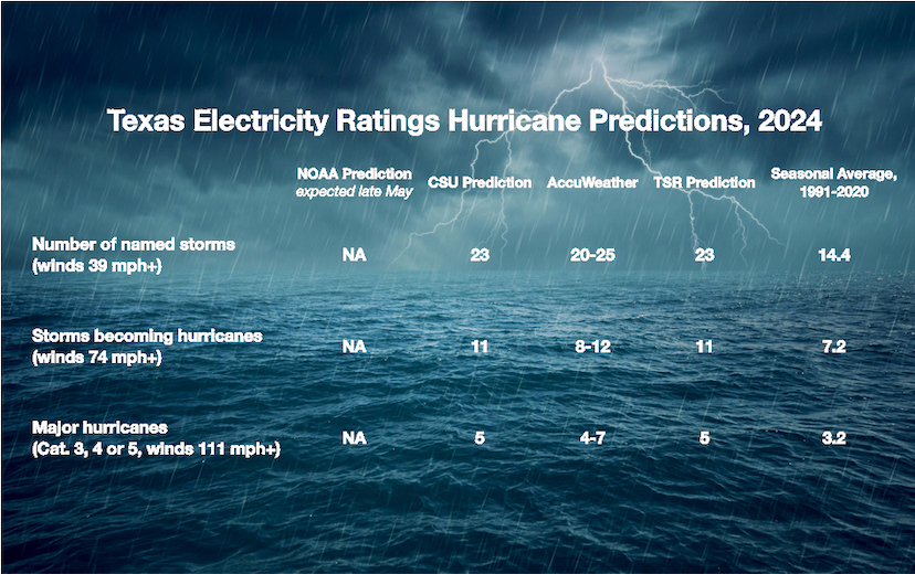
- AccuWeather’s March 27 forecast warns of an “explosive season” where forecasters may even run out of names.
- Tropical Storm Risk (TSR), which makes forecasts in December, released their updated prediction on April 8.
- Colorado State University researchers released their annual hurricane forecast on April 8, also.
- NOAA’s Climate Prediction Center (CPC) usually releases forecasts in late May.
Given this past year’s record warm temperatures and a La Niña expected to emerge in the Pacific Ocean, these weather services now expect “a very active” hurricane season ahead.
Are Hurricane Predictions Accurate?
Bear in mind that storm predictions are based on the probability for tropical storms to spin up. So, predicted storm numbers are not iron-clad. But while some year’s predict too many; over the past 30 years, we’re seeing predictions fall short. For example, the 2023 hurricane season forecast only 13 tropical storms. But due exceptionally warm sea surface temperatures (SSTs), there were 20 and it became the fourth most active season on record. Dire-sounding yes, but of the 20 tropical storms that formed, only three made landfall in North America. Several stayed at sea and disipated as they wandered north.
However, there have been more extremely active hurricane seasons since 1995 than there has been since 1900. And two of the most active seasons occurred in 2005 with 28 storms and 2020 with 30 — eleven of which made landfall in the US causing $37 billion in damage.
With all that in mind, the 23 tropical storms predicted this year is twice as many tropical storms that occur during a statistically “normal” season. So, the consensus in these predictions for the possible number of storms is compelling. As we’ll see, conditions going into the 2024 season have more in common with 2020 than last year.
Why So Many Storms?
Tropical storm systems need three things to spin up:
LOTS of calm, warm water. Tropical storms form when SSTs are at least 80°F (26.5°C) to a depth of about 150 feet.
Dry, thirsty air. When a firm, dry trade wind blows across warm sea water (at about 11 mph), it has an easy time evaporating that water and taking on its heat. As this warm, humid air begins to move upwards and organize, it can quickly develop into a moist and unstable atmosphere that supports sustained shower and thunderstorms which build into tropical storm systems.
A nice, calm upper atmosphere. Tropical storms like winds that move horizontally and spiral up in nice, stacked layers (think stack of pancakes). Vertical winds that cut or shear across that horizontal structure can tear it apart. Wind shearing happens everywhere but as long as it’s about 23 mph from the ocean surface all the way up to around 60,000 feet, the tropical storm will be fine.
The ENSO (El Niño/Southern Oscillation) also plays a role. To be clear, El Niño, ENSO Neutral, and La Niña don’t prevent or cause hurricanes. Rather, it is an ocean-atmosphere system at the equator in the Pacific Ocean that can shift the atmosphere’s circulation (called the “Walker Circulation”). El Niños usually produce wind shears in the Atlantic that blow apart tropical storms or shift them to the middle of Atlantic (as we saw in 2023). ENSO Neutral and La Niñas, however, move those wind-shear patterns far to the east. This leaves a nice, calm upper atmosphere over the Atlantic where tropical storms can develop.
Current Conditions
This past February saw record warm global temperatures, especially in the Atlantic Ocean. Currently, Atlantic SSTs remain warm. In fact, there’s a band of 80°F (26.5°C) water stretching all way from west Africa to the west coast of Cuba. All three hurricane predictions cite these warmer than normal SSTs as a reason for more storms. And given NOAA’s temperature predictions for the summer, it looks like much of the US Atlantic coast will stay like bathwater. That may sound like good news for beach goers (and sharks) but it’s also perfect for building tropical storms.
There is a lot of dry air coming off the African west coast. Actually, too much right now. The Saharan Air Layer (SAL) lies about 5,000 and 20,000 feet up in the sky and transports plumes of dry, dust-laden air from west Africa to as far west as Texas. It usually forms in the late spring/early summer when hot dry winds blow across the Sahara desert and move over the Atlantic Ocean. As result, the SAL can impede tropical storm formation:
- Big dust plumes can warm the atmosphere but block sunlight from warming the ocean surface below. That reduces evaporation.
- The dry air can create down drafts or sinking air. These can interfere with moist air rising and organizing into low pressure systems.
- SAL winds are strong enough to carry dust. So, their winds can also produce vertical wind shears that blow out storm formation.
Although the SAL begins in the spring it doesn’t blow all summer long. All the same, in both 2022 and 2023, the SAL helped keep a lid on storm formation from late May almost through July. The pattern peaks in June and fades in early August. Each plume usually last 3 to 5 days. But once the SAL pattern ends, a warm ocean can spin up a storm in only a few days, if not hours.
All three hurricane predictions also cite the weakening El Niño. This shows that SSTs in the middle of the Pacific Ocean at the equator are getting cooler. NOAA predicts it will cool to ENSO Neutral conditions between April and June. Already, cooler water temperatures as deep as 200 feet are being detected in the eastern Pacific. So change is coming.
While ENSO Neutral means there’s no giant mass of warm or cold water in the Pacific affecting the atmosphere, it allows other atmospheric conditions to exert a bigger influence on hurricane seasons. From 2016 through 2020, summer time ENSO Neutral conditions produced some of the most active hurricane seasons on record. In fact, some of the biggest and deadliest storms to hit the US occurred during ENSO Neutral conditions: Hurricane Harvey (2017), Hurricanes Katrina and Rita (2005), and Tropical Storm Alison (2001).
NOAA predicts a 70% to 80% chance for La Niña to emerge in August. Again, all three hurricane predictions suggest this La Niña may align the three conditions that spawn the most tropical storms. And in many ways, this suggests similarities to the 2020 season.
Hurricane season 2020 began with above average SSTs in the Atlantic. Trade winds were also calm to weak across most of the Atlantic. And lastly, ENSO Neutral was firmly in place and would slowly turn into La Niña by autumn; so there was little wind shear. Some tropical storms first formed at a liesurely pace from mid-May to June. But in mid-July, storm systems began forming in bursts. The most occured in September. At one point there were five named storms spinning in the Atlantic. All told, 2020 saw 30 tropical storms. Eleven struck the US; six of them were hurricanes.
So August and September could be dangerously busy.

Predictions for a Hurricane Hitting the US in 2024
Because hurricanes are creatures of heat, water, and wind they are reliably unpredictable. Once they spin up we can only guess where they probably will go. After all, these storm systems form in an area that stretches from the west coast of Africa all the way to the western shore of the Gulf of Mexico. That said, given the conditions and the number and strength of the storms forecast, it’s logical to anticipate a few coming ashore. But, predicting just how many with any accuracy is a dicey gamble.
- NOAA predictions usually don’t predict landfalls.
- CSU also does not predict the number of landfalls but estimates probability. For example, this year, they estimate a 62% chance for a storm making landfall somewhere along the the entire (Atlantic) US coastline.
- Accuweather forecast that the US will see 4-6 direct impacts.
- TSR says 4.6 tropical storms or hurricanes will come ashore.
One other important thing to remember here is that electricity prices in Texas could surge if tropical storms shut down off-shore natural gas production in the Gulf of Mexico. Some natural gas platforms are located more than 100 miles from shore.
Tropical Storms – What Are the Biggest Dangers?
When tropical storms and hurricanes come ashore, coastal residents face the greatest danger from storm surges. Because of increasingly higher tides, storm surges are now more likely to cause flooding in any coastal city, including those in major bays and estuaries. Texas and other Gulf coast states have seen past storm surges as high a 10 to 24 feet deep that move inland for miles. So residents living on the coast will face a good chance of needing to evacuate at some point this summer.
Because water and heat fuel these storms, they lose power once they move inland. But that doesn’t lessen their danger. Inland residents also face high winds, tornados, and flooding. Weakened cyclones can also turn into slow moving storm systems that dump enormous amounts of rain as they go. This makes flash flooding more likely and extremely dangerous in areas like central and west Texas.
How You Can Prepare for the 2024 Texas Hurricane Season
Texas Electricity Ratings is a Houston company. We’ve all been through the high winds, rain, and electricity outages from some very tough hurricanes. We know that powerful storms can affect any part of Texas so we want everyone to stay safe. So before the first big storm comes ashore, now’s the time to find out what you can do to keep your family safe.
- Make a plan so your family knows for what to do when a dangerous storm comes your way.
- Make a Hurricane Emergency Checklist to help you keep track of how to prepare and what supplies you’ll need if you choose to shelter in place.
- Build your hurricane disaster kit. Make sure every person and pet in your home has everything they need to get through a disaster.
- Gather essential stuff for your Grab-N-Go bag. Each person (and pet) should have their own in case you need to leave your home and evacuate to stay safe.
- Review and understand Texas evacuation routes ahead of time. Make arrangements well ahead of time where you’ll go to in the event of an evacuation order.

