the Texas hurricane season roars back to life!
Learn what’s behind it and what you can expect.
—Image courtesy of NOAA
What Texas Hurricane Season?
We should be in the middle of a strong hurricane season. But if you’ve looked for storm systems in the Atlantic and the Gulf of Mexico over the past two months, there’s been total nada happening. In the wake of Hurricane Harvey one year ago, the dearth of tropical cyclones has been a welcome respite from Texas electricity supply outages.
What happened to the “above-normal” hurricane season?
Remember back in the May hurricane prediction that there was uncertainty about how warm sea surface temperatures (SSTs) in the Main Development Region (MDR) would get this summer? NOAA’s computer weather models suggested the possibility that the Atlantic could stay cooler this summer. Well, that possibility became a reality; no warm water = no hurricanes.
The air was also far too dry. When tropical waves roll out of the Sahara they become the platform for hurricanes. The hot dry air gets over warm sea water and causes LOTS of evaporation that forms into clouds and eventually storms. This year, however, strong trade winds were blowing from Africa making the air drier than normal. Couple that with cooler sea water and there was less evaporation. Therefore, there was a low rate of energy available to build clouds and develop storms.
There’s also been a lot of hot weather rolling eastwards across the U.S. which has been causing strong wind shearing in the MDR— the kind that prevents tropical storms from forming. Tropical storm systems rely on the heat from warm ocean water moving upwards and carrying evaporated water with it in a nice, stable column. Wind shear destabilizes that column structure and can eventually dissipate the storm.
So that’s why there’s been practically no hurricane season. In fact, NOAA released its August 9 Hurricane Season Update saying the season was in fact expected to be “less active season than was predicted in May. A below-normal or near-normal season is now predicted”.
But their model predictions for sea surface temperatures and wind shearing produced a lot of uncertainty for the rest of the season. And as it turns out, temperatures in the MDR recently rose above the 26.5°C (79.7°F) threshold for tropical storm formation. There are also signs that wind shear trend might have begun dissipating over the MDR. Together, these would increase the chance for tropical storm formation, especially in the Gulf of Mexico where SSTs are very warm.
And right on cue, the storms are already firing up!
OH—THAT Texas Hurricane Season!
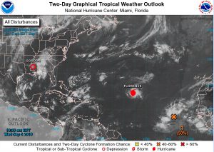
On August 31, the National Hurricane Center website saw two disturbances already forming; Potential Tropical Cyclone Six off the coast of west Africa and Disturbance 1, northwest of Puerto Rico and heading west-northwest. By September 5, Disturbance 1 had grown to become Tropical Storm Gordon and came ashore near Biloxi, Mississippi and Cyclone Six blew up to become Hurricane Florence, a category 3 storm with 125 mph sustained winds. And now’s there’s a NEW Disturbance 1 southwest of the Cabo Verde islands that is expected to become a storm system within 5 days.
For the remaining hurricane season months, NOAA expects the possibility for an additional 5-9 named storms, with 2-5 becoming hurricanes and 0-2 of those becoming major (category 3-5) hurricanes.
It Only Takes One Storm
No matter when they strike, tropical storms and hurricanes are always serious threats. The important thing, however, is to be prepared just in case. Tropical storms and hurricanes don’t end as soon as they come ashore — they often wander far inland, bringing torrential rains, flooding, and tornados.
Learn to keep your family safe when your Texas city electricity goes out. Start preparing for the worst storm now. Have a plan and make a checklist of supplies that you’ll need. Learn about rules covering Texas evacuation routes especially in areas near the Gulf and the Houston Metro area. Be sure to check out Ready.gov for more information on how you can weather these summer storms.
